An amazing video has been digitized of the historic Spiral Bridge in Hastings, showing it in use before its demolition, and a brief shot of its demise. You can check it out here. Thanks to Cathy Wurzer for posting this on the Tales of the Road facebook page!
Tag: Old Trunk Highway Alignments
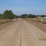
New Photos of Old Highway 28 at Westport

Just added a few new photos to the “Old Highway 28” article from a visit I made in February. Sadly, the historic Westport signs on the edges of town have been stripped of their 1960 census populations, and new green name plates have been bolted on.
New Article – Old Highway 28 at Westport

Click the image above to see the article on Highway 28’s old route through the tiny town of Westport in rural Pope County Minnesota.
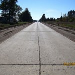
Historic Concrete Pavement on Old 61 Revealed!!
Jeff Wulke was kind enough to share the following photos of what is now Chisago County Road 30 (former MN 361, U.S. 61) between Rush City and Pine Creek, where crews have temporarily stripped away the asphalt to reveal the historic original concrete pavement from the 1920’s!! The concrete was poured back in 1927 as part of the first paved highway between the Twin Cities and Duluth, and was covered when the road was widened and rebuilt in 1954. As you can see from the photos, the old road is in remarkably good condition. This stretch was recently turned back to county authorities after remaining under state jurisdiction as State Highway 361 for many years after I-35 was built to fulfill a legal obligation dating back to 1921 to have a trunk highway passing through the city limits of Rush City, which has since been expanded to encompass I-35. Many thanks again to Jeff for the photos!!


U.S. 65 asks: “why does U.S. 61 get to have all the fun?”
The first of many new articles on historic U.S. 65 is now up over at the U.S. 65 project! I’ve been sitting on quite a few photos I took last year, and I thought it was time to let U.S. 65 get out from under U.S. 61’s shadow. The first article gives a photo-tour of the old road between Albert Lea and the Iowa border.

U.S. 61 Page Update and New Articles
Just finished a major update to the U.S. 61 section of the page to bring it up the snuff with the new routes being added. I also threw in a couple of brand new articles on old alignments along the north shore for good measure (click on the sample photos below to see them).
Back in April I undertook my first “overnight” expedition, photographing old alignments along the north shore for two days, with a night out in Two Harbors in-between (watch out for those $1 PBR’s, they’ll kill ya!) I have a ton of photos and articles to add in the next couple of months, so rest assured, these two are just the tip of the iceberg!


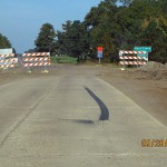
New Historic U.S. 61 Article: 1st Street, Forest Lake
Another new article at the U.S. 61 project! All visible historic alignments of U.S. 61 along its modern extent in Minnesota are now documented and photographed. Next project? Articles on the historic junctions and roadside structures along the same stretch! Photos have thankfully already been taken for this section, so it shouldn’t take to long to start posting them – stay tuned!
Click on the photo below to see the new article!

Two more Historic U.S. 61 Alignment Articles.
Two more with photos and maps! Click on the photos below!


Three New Historic U.S. 61 Articles, All in Maplewood!
Hello all. Three more articles added tonight. Enjoy!


New Historic U.S. 61 Article: Old Alignment at Phalen-Keller Regional Park, Maplewood
Brand new article with photos, etc! I also just completed a revamp of the historic U.S. 61 articles, correcting a few design issues etc.

