Academic History
-
Currently enrolled in the Master of Geographic Information System Program, University of Minnesota-Twin Cities, 2011-Present.
-
Non-degree seeking course work in Geographic Information Systems, University of Minnesota-Twin Cities, 2006-2007.
-
BS, Geography, University of Minnesota-Twin Cities, 2003.
Examples of Graduate-Level Academic Work
 |
Using Shortest Path Analysis with Raster Data for Highway Planning: Designing a Bypass for Hastings, Minnesota (PDF)Presentation poster outlining the process of designing a highway bypass for the town of Hastings, Minnesota using "Shortest Path" analysis with raster GIS data. Details the creation of a "cost" data layer using a subjective weighing of existing data sets, and displays a proposed highway network. All work done in ArcGIS |
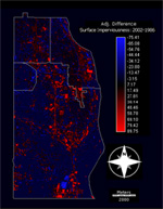 |
Pairwise Change Analysis Techniques for Quantitative Geographic Data: A Survey of Techniques Introduced in the United Nations Institute for Training and Research (UNITAR) Workbook (PDF)Technical report detailing techniques for pairwise change analysis using both data provided by UNITAR on a continental scale, and an added analysis using city-scale data for the southeast suburbs of the Twin Cities. Analysis and maps done in IDRISI Andes. |