
 U.S. Highway 61 - Concrete Paving Project Timeline, 1921-1939
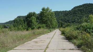
A surviving stretch of 18-foot wide concrete south of
Weaver in Wabasha County. This concrete was laid in
1925 as part of the construction of State Route 3, one
year before U.S. 61 was first marked.The following is a timeline of the early concrete (and asphalt on concrete) paving projects conducted by the Minnesota Department of Highways along U.S. 61. Dates generally refer to the year of contract completion given on the highway construction project logs. Projects for each year are listed from south to north. Each paving project is labeled with the region of U.S. 61's route it was contained in (SE, C, or NE).
Concrete pavement was generally used on the more important early highways in Minnesota, including on nearly all of U.S. 61's route between the Wisconsin state line and Two Harbors (the remainder of the highway along the north shore was paved with asphalt or bituminous pavement.) The original standard concrete pavement design was 18 feet wide. The highway department switched to a 20 foot standard in 1929. The original design was done away with in the late 30's - the last standard design concrete pavement constructed on U.S. 61 was on the hill west of Red Wing in 1939.
The largest burst of paving activity occurred between 1925 and 1927, with 1926 having the most miles paved (92.14 miles). None of the original era concrete pavement is in use as a trunk highway today - all of it has been bypassed by more modern roads or paved over.
Timeline
1920
- SE - From East Street in downtown Red Wing to the future junction with State Highway 19 - Concrete (variable, but generally 18') - 5.33 miles.
Total: 5.33 miles.
1921
- SE - 2nd (Main) Street in Hastings and Sibley Street (Spiral Bridge Connection) - Bituminous Concrete - 0.10 miles.
- C - St. Paul City Limits to County Road 'E' in Gem Lake - Asphalt on Concrete (24') - 4.56 miles.
- C - Otter Lake Road in Gem Lake to White Bear Lake - Asphalt on Concrete (24') - 0.82 miles.
Total: 5.48 miles. Breakdown by Region - SE: 0.10 miles. C: 5.38 miles.
1922
- C - County Road 'E' to Otter Lake Road in Gem Lake - Asphalt on Concrete (24') - 1.24 miles.
Total: 1.24 miles.
1923
- C - Carlton / St. Louis County Line to the Duluth City Limits (part constructed by St. Louis County) - 18' - 4.75 miles.
- NE - East city limits of Duluth to the St. Louis / Lake County Line - 18' - 7.91 miles.
Total: 12.66 miles. Breakdown by Region - C: 4.75 miles. NE: 7.91 miles.
1924
- SE - Lyon Avenue in Lake City to the west corporate limits - Concrete (18') - 3.16 miles.
- SE - East corporate limits of Red Wing to Plum and 4th Streets - Concrete (18') - 2.08 miles.
- C - Lake Avenue in White Bear Lake - Asphaltic Concrete (24' - 28') - 1.09 miles.
- C - Freisland to Sandstone - 18' - 4.78 miles.
- C - Carlton to the Carlton / St. Louis County Line - 18" - 8.61 miles.
Total: 19.72 miles. Breakdown by Region - SE: 5.24 miles. C: 14.48 miles.
1925
- SE - Wisconsin State Line to 4th Street in La Crescent - 18' -22' - 2.13 miles.
- SE - Winona / Wabasha County Line at Minneiska to Kellogg - 18' - 11.24 miles.
- SE - Between the corporate limits of Lake City and Red Wing - Concrete (18') - 11.65 miles.
- SE - St. Paul Park to the St. Paul corporate limits - 18' - 4.71 miles.
- C - In Hugo, between 125th Street and 175th Street - 18' - 5.11 miles.
- C - Rock Creek to Pine City - 18' - 5.15 miles.
Total: 39.99 miles. Breakdown by Region - SE: 29.73 miles. C: 10.26 miles.
1926
- SE - Pleasant Valley Creek to St. Mary's Cemetery at Winona - Concrete (18') - 0.90 miles.
- SE - Villa and Broadway in Winona to the Winona / Wabasha County Line - 18' - 14.5 miles.
- SE - Kellogg to Wabasha - 18' - 5.99 miles.
- C - White Bear Lake (intersection of Lake Ave and Stewart) to 125th Street in Hugo - 18' - 3.34 miles.
- C - 175th Street on the north side of Hugo to the north side of Wyoming - 18' - 10.53 miles.
- C - Short segment in Pine City - 18' - 0.18 miles.
- C - Mission Creek to Friesland - 18' - 9.31 miles.
- C - Sandstone to Carlton - 18' - 47.39 miles.
Total: 92.14 miles. Breakdown by Region - SE: 21.39 miles. C: 70.75 miles.
1927
- SE - 4th Street in La Crescent to La Moille - Concrete (18') - 15.61 miles.
- SE - Vermillion Street in Hastings - (variable width) - 1.52 miles.
- SE - Manning Avenue (future Hwy. 95) to St. Paul Park - 18' - 6.57 miles.
- C - Wyoming to Rock Creek - 18' - 28.57 miles.
- C - Pine City to Mission Creek - 18' - 8.4 miles.
Total: 60.67 miles. Breakdown by Region - SE: 23.7 miles. C: 36.97 miles.
1929
- SE - La Moille to Pleasant Valley Creek at Winona - Concrete (20') - 6.51 miles.
- SE - St. Mary's Cemetery to a point just north of the modern jct. of U.S. 61 with Hwy. 43 at Winona - (20' to 40') - 0.79 miles.
- SE - The intersection of Mankato Avenue and Sarnia Street to Junction Street and Broadway in Winona - (20' to 40') - 3.3 miles.
- NE - St. Louis / Lake County Line to Two Harbors - 20' - 8.35 miles.
Total: 18.95 miles. Breakdown by Region - SE: 10.6 miles. NE: 8.35 miles.
1931
- SE - The future south junction with Highway 316 to Hastings - 20' - 12.49 miles.
- SE - Spiral Bridge at Hastings to Manning Avenue (future Hwy. 95) - 20' - 1.29 miles.
Total: 13.78 miles.
1932
- SE - New bridge approach at the Wisconsin State Line - 20' - 0.12 miles.
- SE - Highway 19 to the future south junction with Highway 316 - 20' - 7.79 miles.
Total: 7.91 miles.
1936
- SE - Curve at the modern junction of Winona County Roads 15 and 17 at Winona - 20' - 0.30 miles.
- SE - Mankato Avenue in Winona, just north of the modern jct. of U.S. 61 with Hwy. 43 to Sarnia Street - 40' - .38 miles.
- SE - Wabasha to Lake City - 20' - 14.21 miles.
- SE - At the Lake Pepin viewing area north of Lake City (realignment) - 20' - .34 miles.
- SE - Curve and new bridge at Wells Creek between Lake City and Red Wing -20' - 0.99 miles.
Total: 16.22 miles.
1937
- C - New alignment at White Bear Lake (partially divided) - generally 20' driving lanes - 1.35 miles.
Total: 1.35 miles.
1939
- SE - Plum Street in Red Wing between Main Street and 4th Street, Main Street for two blocks west of Main - (variable width) - 0.30 miles.
- SE - Spring Creek in Red Wing to Highway 19 - Concrete (20') - 2.42 miles.
Total: 2.72 miles.
Geographic Timeline (South to North)
Paving projects that replaced earlier concrete pavements are in bold. Explanations of the replacements follow in italics.
- 1932 - New bridge approach at the Wisconsin State Line - 20' - 0.12 miles. Replaced short section of 1925 pavement.
- 1925- Wisconsin State Line to 4th Street in La Crescent - 18' -22' - 2.13 miles.
- 1927 - 4th Street in La Crescent to La Moille - Concrete (18') - 15.61 miles.
- 1929 - La Moille to Pleasant Valley Creek at Winona - Concrete (20') - 6.51 miles.
- 1926 - Pleasant Valley Creek to St. Mary's Cemetery at Winona - Concrete (18') - 0.90 miles.
- 1936 - Curve at the modern junction of Winona County Roads 15 and 17 at Winona - 20' - 0.30 miles. Replaced section paved in 1926 and 1929.
- 1929 - St. Mary's Cemetery to a point just north of the modern jct. of U.S. 61 with Hwy. 43 at Winona - (20' to 40') - 0.79 miles.
- 1936 - Mankato Avenue in Winona, just north of the modern jct. of U.S. 61 with Hwy. 43 to Sarnia Street - 40' - .38 miles.
- 1929 - The intersection of Mankato Avenue and Sarnia Street to Junction Street and Broadway in Winona - (20' to 40') - 3.3 miles. Replaced 1926 pavement on Broadway west of Villa.
- 1926 - Villa and Broadway in Winona to the Winona / Wabasha County Line - 18' - 14.5 miles.
- 1925 - Winona / Wabasha County Line at Minneiska to Kellogg - 18' - 11.24 miles.
- 1926 - Kellogg to Wabasha - 18' - 5.99 miles.
- 1936 - Wabasha to Lake City - 20' - 14.21 miles. - Replaced city streets in Wabasha paved in 1926.
- 1924 - Lyon Avenue in Lake City to the west corporate limits - Concrete (18') - 3.16 miles.
- 1924 - East corporate limits of Red Wing to Plum and 4th Streets - Concrete (18') - 2.08 miles.
- 1925 - Between the corporate limits of Lake City and Red Wing - Concrete (18') - 11.65 miles.
- 1936 - At the Lake Pepin viewing area north of Lake City (realignment) - 20' - .34 miles. - Replaced 1925 pavement.
- 1936 - Curve and new bridge at Wells Creek between Lake City and Red Wing -20' - 0.99 miles. - Replaced 1925 pavement.
- 1937 - Plum Street in Red Wing between Main Street and 4th Street, Main Street for two blocks west of Main - (variable width) - 0.30 miles.
- 1920 - From East Street in downtown Red Wing to the future junction with State Highway 19 - Concrete (variable, but generally 18') - 5.33 miles.
- 1939 - Spring Creek in Red Wing to Highway 19 - Concrete (20') - 2.42 miles. - Replaced 1920 pavement.
- 1932 - Highway 19 to the future south junction with Highway 316 - 20' - 7.79 miles.
- 1931 - The future south junction with Highway 316 to Hastings - 20' - 12.49 miles.
- 1927 - Vermillion Street in Hastings - (variable width) - 1.52 miles.
- 1921 - 2nd (Main) Street in Hastings and Sibley Street (Spiral Bridge Connection) - Bituminous Concrete - 0.10 miles.
- GAP - Short bituminous section at the north end of the spiral bridge.
- 1931 - Spiral Bridge at Hastings to Manning Avenue (future Hwy. 95) - 20' - 1.29 miles.
- 1927 - Manning Avenue (future Hwy. 95) to St. Paul Park - 18' - 6.57 miles.
- 1925 - St. Paul Park to the St. Paul corporate limits - 18' - 4.71 miles.
- GAP - City streets in St. Paul.
- 1921 - St. Paul City Limits to County Road 'E' in Gem Lake - Asphalt on Concrete (24') - 4.56 miles.
- 1922 - County Road 'E' to Otter Lake Road in Gem Lake - Asphalt on Concrete (24') - 1.24 miles.
- 1921 - Otter Lake Road in Gem Lake to White Bear Lake - Asphalt on Concrete (24') - 0.82 miles.
- 1937 - New alignment at White Bear Lake (partially divided) - generally 20' driving lanes - 1.35 miles. - Replaced 1924 and 1926 pavements in White Bear Lake.
- 1924 - Lake Avenue in White Bear Lake - Asphaltic Concrete (24' - 28') - 1.09 miles. - Replaced the north end of the 1921 pavement.
- 1926 - White Bear Lake (intersection of Lake Ave and Stewart) to 125th Street in Hugo - 18' - 3.34 miles.
- 1925 - In Hugo, between 125th Street and 175th Street - 18' - 5.11 miles.
- 1926 - 175th Street on the north side of Hugo to the north side of Wyoming - 18' - 10.53 miles.
- 1927 - Wyoming to Rock Creek - 18' - 28.57 miles.
- 1925 - Rock Creek to Pine City - 18' - 5.15 miles.
- 1926 - Short segment in Pine City - 18' - 0.18 miles.
- 1927 - Pine City to Mission Creek - 18' - 8.4 miles.
- 1926 - Mission Creek to Friesland - 18' - 9.31 miles.
- 1924 - Freisland to Sandstone - 18' - 4.78 miles.
- 1926 - Sandstone to Carlton - 18' - 47.39 miles.
- 1924 - Carlton to the Carlton / St. Louis County Line - 18" - 8.61 miles.
- 1923 - Carlton / St. Louis County Line to the Duluth City Limits (part constructed by St. Louis County) - 18' - 4.75 miles.
- GAP - City streets in Duluth.
- 1923 - East city limits of Duluth to the St. Louis / Lake County Line - 18' - 7.91 miles.
- 1929 - St. Louis / Lake County Line to Two Harbors - 20' - 8.35 miles.