
 Historic U.S. 61: Sugar Loaf Road, Winona
Sugar Loaf Road
Located In: City of Winona, Winona County
Bypassed: 1929
Length: 0.71 miles
Also Marked As:
 1921-1929
 1929-1933*
* North of the old
jct. with U.S. 61 only.
Sugarloaf Road on the southeast side of Winona was once part of U.S. 61's original alignment. The surviving segment runs parallel with Homer Road (Highway 43 and County Road 17) past the Sugarloaf Hill. It once connected directly with Mankato Avenue on the north, and with Homer Road on the south.

Construction
Sugarloaf Road was originally paved with brick by the city of Winona at an unknown date before 1921.
Bypass History
In 1929, the Department of Highways replaced the old brick road at the southeast entrance to Winona with a modern concrete road, aligned along what are now parts of State Highway 43 and County Road 17.
Current Status
After being bypassed, the section of the old road north of East Burns Valley Road was taken over by State Highway 43. Highway 43 was moved off of Sugarloaf Road onto its current alignment in 1933.
1956 aerial photos from just before the construction of the modern four-lane highway show that the old alignment had remained intact after being bypassed. From construction plans, it appears that at least some of the brick was still exposed in the late 1950's. The north connection to Mankato Avenue was removed during the construction of the modern divided highway. In the years since, all of the old brick has either been paved over or destroyed by further development. A small section of the old road between State Highway 43 and East Burns Valley Road is now the northern end of County Road 105.
Historic Junction: 1926-1929
The site of U.S. 61's original junction with State Highway 43 was just south of modern Highway 43 on Sugar Loaf Road at the old north end of East Burns Valley Road. East Burns Valley Road's north end was eventually realigned to avoid an old crossing of the creek. Highway 43 was moved to its current alignment up the West Burns Valley in 1933.
Photo Tour - Photos taken in October, 2007.

Looking south at the modern junction of U.S. 61/U.S. 14 with State Highway
43. All three alignments of U.S. 61 through this area are visible. The original
alignment on Sugar Loaf Road is visible on the far right, ascending the hill.
The second alignment, now State Highway 43, is on the far left. The modern
four lane road used by U.S. 61 and U.S. 14 runs across the photo.
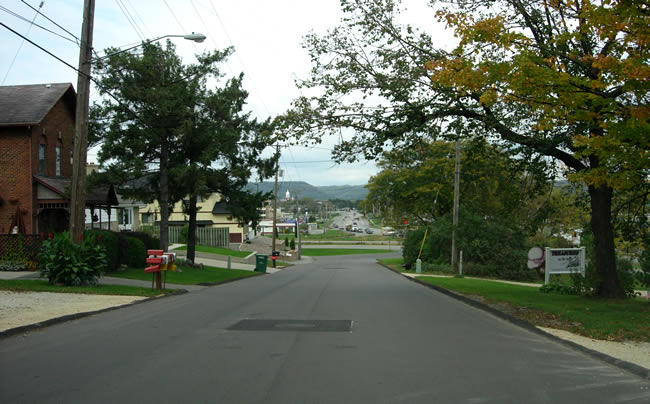
Looking back to the north on Sugar Loaf Road towards Winona. Note how Sugar
Loaf road is directly aligned with Mankato Avenue in the distance.

Looking south on Sugar Loaf Road at the intersection with Old West Burns Valley
Road. Highway 43 is just ahead (at the tan shed
like building in the distance).

Looking south on Sugar Loaf Road, just south of Highway 43.

At the original junction with Highway 43, 1926-1929.
Highway 43's original alignment, on the right, no longer connects with East
Burns Valley Road as it once did. It was bypassed in 1933.

Looking southeast at the bridge over East Burns Valley Creek. The old road
ends on the other side of the bridge, replaced by parking lots and modern
County Road 105. The bridge (#L1386) was constructed
in 1939 to replace the bridge (#4161) used by U.S. 61.