
Home >> Projects >> U.S. 61 >> Modern Highway Photo Galleries
 Modern Highway Photos: Through St. Paul's East Side
May, 2007 (Page 1)
Page Index
- Page 1 - The West Junction with Interstate 94 / U.S. 10 / U.S. 12 at Mounds Boulevard
- Page 2 - Mounds Boulevard
- Page 3 - East 7th Street
- Page 4 - Arcade Street
- Page 5 - St. Paul to State Highway 36
The following series of photos feature U.S. 61's route through the east side of St. Paul (plus a bit in Maplewood). They were taken on a sunny sunday morning while storm clouds loomed on the horizon. The section of U.S. 61's route shown here is currently a turn-back candidate, meaning it may not be with us for much longer!
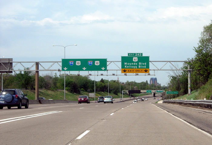
Westbound on the Interstate 94/U.S. 61/U.S. 10/U.S. 12 (not marked) multiplex
at Johnson Parkway in St. Paul. This section of I-94 was completed in 1975,
replacing an earlier divided expressway constructed in 1949. Traffic on northbound
U.S. 61 is directed to use the two right lanes to exit onto Mounds Boulevard.

More signage for the upcoming exit on the Earl Street overpass.

At the west junction with I-94, U.S. 10, and U.S. 12 (not marked), about to
exit onto Mounds Boulevard. The Mounds Boulevard overpass (used by southbound
U.S. 61) is visible ahead. The Minnesota State Capitol's dome is also just
visible on the right.

Direction signage on the off-ramp to Mounds Boulevard. The Mounds Boulevard
interchange with I-94, originally constructed in 1966, was rebuilt with the
same overall configuration in 1988.

The west junction with I-94/U.S. 10/U.S. 12 (unmarked) as seen from U.S. 61
southbound, looking south on the Mounds Boulevard overpass. The bridge was
constructed in 1988 to replace the original structure built in 1966.

Another view of the southbound interchange, looking north from Mounds Boulevard
towards the overpass.

I-94 route markers at Mounds Boulevard. Notice how the eastbound sign is the
old style, with "Minnesota" printed above the number. Also note
the sign directing traffic to westbound I-94. Access to westbound I-94 is
provided via ramps at 6th Street, several blocks to the north.

Looking east down the southbound U.S. 61 entrance ramp to I-94.
>> Next Page
>> Page Index
- Page 1 - The West Junction with Interstate 94 / U.S. 10 / U.S. 12 at Mounds Boulevard
- Page 2 - Mounds Boulevard
- Page 3 - East 7th Street
- Page 4 - Arcade Street
- Page 5 - St. Paul to State Highway 36
>> Back to the Photo Gallery Index
>> back to top