Blog: Page Updates and Communication

Historic Minnesota Highways Interactive Map Prototype Is Up!

intmapfeb2015

Try the map out!

A prototype of the map I have been working on (see previous post here) showing only data for Hennepin County is now available. I put this together quickly, so there is no functionality other than what is already built into Google Maps. You can click any of the highway lines for information on that historic corridor. I still need to nail down the data model, the visualization, and what pops up when you click on a line. I hope to add some customization to the view of the data (limiting by year in use, route, etc). This will all take time, but at least you can do a little exploring if you’re bored at work this week.

A Winter’s Work

working-feb1
Hello fellow historic highway travelers. You may (or may not) have been asking what the heck I’ve been up to the last few weeks in terms of new content for the site. Well, I finally got my graduate degree, so that won’t be getting in the way any more…but now I guess its time to work on some projects for the site while I figure out what to do with the rest of my life.

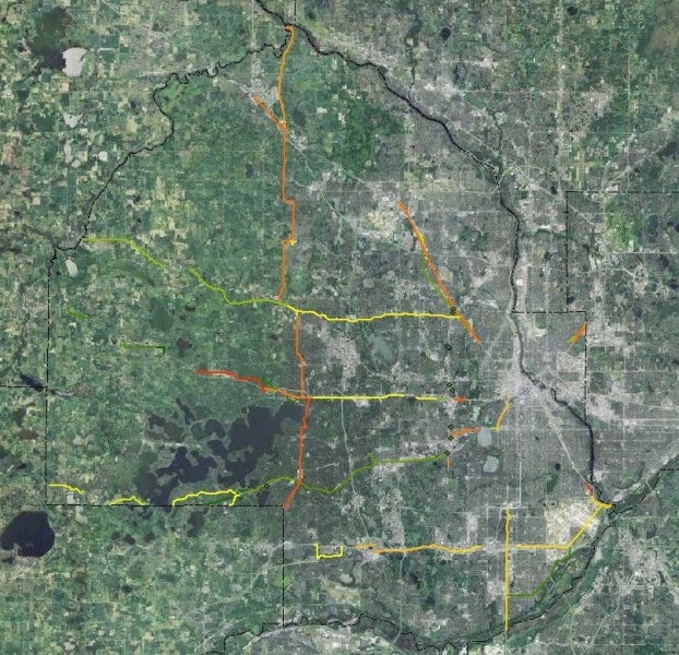
Right now I’m working on the initial data for a web map that I’m tentatively calling “Historic Trunk-Highway Corridors of Minnesota”. My plan is that it will act as a kind of big-picture map for the whole state, showing a summary of the old highway corridors state-wide. It won’t be showing every single little alignment change (the scale of that project would be too much for me alone), but instead will allow you to explore your neck of the woods (or urban jungle) and see if there is anything historic nearby for you to explore. I’m also planning for the map to have locations of historic roadsides (both surviving and lost), as well as the locations of interesting bridges of historic significance. Users will also be able to access the various photo-tours and articles from the map. In summary, the map will eventually allow you to access nearly all the information on the site.

Work on this map is going to be done one county at a time. I’m starting with Hennepin County (my home county), home to nearly 22% of Minnesota’s population, and working my way out from there. I’m hoping that once I get past the dense urban counties, the work will go faster, as the areas around Minneapolis and St Paul have proven the most challenging in terms of research due to the high density of old highway corridors converging there.

In the mean-time, I’ve got a few more features to do about Highway 100 and some of the historic road-sides, as well as some info about the construction going on in the vicinity of Highway 7. Back to work!

New Article – Historic St Augusta Creek Bridge

Finally got around to posting something new, an article on a historic highway bridge near St Cloud that was bugging me to photograph it every time I passed it while driving back and forth to my friend’s farm via I-94 this summer. Click on the photo above to check it out.

Also, I’ve changed the articles section of the site a bit, consolidating all the articles on the site into one page for easier access. A map with markers for each is included for good measure.

U.S. 65 asks: “why does U.S. 61 get to have all the fun?”

The first of many new articles on historic U.S. 65 is now up over at the U.S. 65 project! I’ve been sitting on quite a few photos I took last year, and I thought it was time to let U.S. 65 get out from under U.S. 61’s shadow. The first article gives a photo-tour of the old road between Albert Lea and the Iowa border.

North Shore Madness!!

Over the last month, I’ve been adding photo-articles on the historic alignments and bridges along the North Shore Scenic Highway between Duluth and Little Marais to the U.S. 61 Project. In all, there are 22 new photo-articles to check out! The photos in the articles were taken in a two-day period back in April, 2010. See the links below:

Finally! The New U.S. 61 Interactive Map is DONE!!

After months of work and technical setbacks, I have finally finished the year-by-year data for the U.S. 61 interactive map. I have also cleaned up and updated the whole U.S. 61 section, wrapping the old historic alignment and roadside sections into one called “Articles“.

For those of you not familiar with the other “year-by-year” maps on the site, this data allows you to see the alignment and paving status of the road in any given year. Changes completed that year are also available for comparison so you can see which sections of road were bypassed or paved each year. A new feature I’ve added with this map is the “Compare-a-Year” feature, which allows you to add the alignment from another year. Finally, an “Articles” layer had been added that allows you to see the locations of all the U.S. 61 articles I’ve posted over the years.

New U.S. 52 map, and future updates

Hello, haven’t updated the blog in awhile, but wanted to let anyone who still checks it what’s going on with the site right now.

About a month ago, I added a new interactive map displaying the history of U.S. 52’s route through Minnesota. I was pretty happy with how it turned out, so I am in the process of trying to get the maps on the older U.S. Highway projects (U.S. 61, 65, 8, and 16) up to the same standard. Its been slow going, however. I’m plugging away on U.S. 61 first, but I don’t expect it to be done for a couple more months. The other routes will follow.

In other news, I’ve been continually going through all of my old highway photos from the past 6 years and uploading them to Flickr (I love Flickr’s geotagging and mapping feature). The photo stream will be continually updated, and will be the first place photos from my highway expeditions show up. The photostream is accessible directly from the main page at deadpioneer.com.

U.S. 61 Page Update and New Articles

Just finished a major update to the U.S. 61 section of the page to bring it up the snuff with the new routes being added. I also threw in a couple of brand new articles on old alignments along the north shore for good measure (click on the sample photos below to see them).

Back in April I undertook my first “overnight” expedition, photographing old alignments along the north shore for two days, with a night out in Two Harbors in-between (watch out for those $1 PBR’s, they’ll kill ya!) I have a ton of photos and articles to add in the next couple of months, so rest assured, these two are just the tip of the iceberg!

Gitchi Gami Trail at Tofte
Private Driveway at Tofte