
 Old Jefferson Highway - Frank Hall Drive and 4th Street in Albert Lea
Old Jefferson Highway - Frank Hall Drive and 4th Street in Albert Lea


Part Of:
1. 2.
- Jefferson Highway.
- Presumed temporary route of Trunk Highway No. 1 as of May 13, 1921 by commissioner's order until bypassed.
Historic Context: Part of early Jefferson Highway between Mason City and Albert Lea.
Length: 1.3 miles
In Use: 1921
Construction: Southern 0.3 miles graded as a county job in 1920. Remainder has no official record of construction.
Bypassed: 1923, by construction of a new southern approach to Albert Lea along modern U.S. 65 and County Road 19.
Status: Intact, rebuilt and paved as city streets.
Last Visited: June 2013.
Tour Navigation
Tour Map

Click on the blue symbols to jump to a point
Jump to...
Related Articles
Frank Hall Drive and 4th Street were once the southeastern gateway to the city of Albert Lea for early motorists traveling to and from Mason City, Iowa on the Jefferson Highway. Although never explicitly shown on any Highway Department documents, this route was specifically spelled out in the 1921 Automobile Blue Book, and was likely the original temporary route of Trunk Highway No 1 starting in 1921. This route into town was retired in 1923 by construction of a new highway that followed what are today County Road 19 and U.S. Highway 65 directly onto Broadway on the south side of town. This removed traffic from residential city streets and got rid of the excess turns required on the old route.
Overview

Frank Hall Drive and 4th Street are now both residential streets and have long sing been rebuilt and paved. Frank Hall Drive was formerly known as Ridge Avenue (per the 1921 Blue Book), and later as Park as shown on Sanborn Insurance Maps. Most of the landscape around the old route has remained pretty much the same, with the exception of the south end which has been filled in with new subdivisions since the early 1920's. There are also several newer homes on the east side of Frank Hall Drive overlooking the lake.
1: Frank Hall Drive at County Road 19

The south end of the old route is now the intersection of County Road 19 with Frank Hall Drive. The Jefferson Highway once curved north here, directing traffic onto Frank Hall Drive and into town (mouse over the map above to see this location in 1938). The two roads now meet at a right-angle, with no indication of Frank Hall Drive's former role.

Looking north on Frank Hall Drive just after turning off of County Road 19.

Houses along Frank Hall Drive, with a fleeting glance
of Albert Lea Lake on the right. Frank Hall Drive curves northwesterly to follow the lake shore.
2: Frank Hall Drive and 4th Street

Traffic entering Albert Lea on the Jefferson Highway once made a turn to the left here at the intersection with 4th Street, which made the connection to Broadway. If motorists missed the turn, the road ahead would have led them onto 2nd Street and ultimately Broadway anyway (why the route on 4th was chosen over 2nd is unknown to me at this time).

Sign for Academy Park, looking west down 4th Street from Frank Hall Drive. The park is named for Luther Academy, which formerly occupied this site. The school was still in operation when 4th Street was part of the Jefferson Highway.

All that remains of the main Luther Academy building is this memorial built from its cornerstone, dedicated by alumni in 1952. The inscription states that the school folded in 1928. The building was presumably demolished shortly thereafter (the 1931 Sanborn Fire Insurance Map show no building here). The site of the building is now occupied by tennis courts.

The former dormitory building of Luther Academy is now an apartment building (looking north from 4th Street).

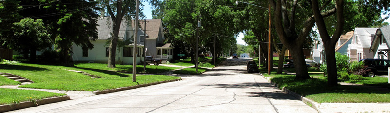
4th Street, looking west towards St John Avenue.
3: 4th Street and Broadway (U.S. 65)

After descending a short steep hill, 4th Street comes to an end at Broadway, now U.S. Highway 65. Northbound traffic on its way into downtown Albert Lea had to turn right ahead.
>> Back to Historic Highway Tours
Sources
- Automobile Blue Book, 1921, Volume 10. Page 380.
- LakesnWoods.com - Albert Lea Minnesota Gallery
- Minnesota Highway Department. Construction Project Log Record: Control Section 2404.
- Rand McNally. Official Auto Trails Map, District No. 9. 1920.
- Sanborn Fire Insurance Maps of Albert Lea, June 1926 and February 1921 (accessed via ProQuest, accessible by agreement with the University of Minnesota).